
Features WiGLE WiFi Wardriving
Open source network observation, positioning, and display client from the worlds largest queryable database of wireless networks.
Can be used for site-survey, security analysis, and competition with your friends.
Collect networks for personal research or upload to https://wigle.net.
WiGLE has been collecting and mapping network data since 2001, and currently has over 350m networks.
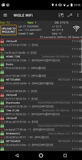
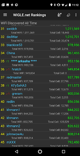
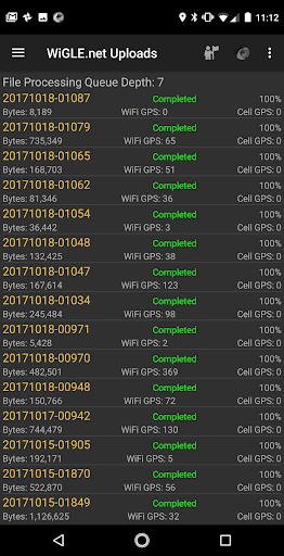
WiGLE is *not* a list of networks you can use.* Uses GPS to estimate locations of observed networks* Observations logged to local database to track your networks found* Upload and compete on the global WiGLE.net leaderboard* Real-time map of networks found, with overlays from entire WiGLE dataset* Free, open source, no ads (pull requestes welcome at https://github.com/wiglenet/wigle-wifi-wardriving )* Export to CSV files on SD card (comma separated values)* Export to KML files on SD card (to import into Google Maps/Earth)* Bluetooth GPS support through mock locations* Audio and Text-to-Speech alerting and "Mute" option to shut off all sound/speechCurrent release notes notes: https://github.com/wiglenet/wigle-wifi-wardriving/blob/master/TODOFeedback and support requests are welcome via email [email protected], github, or https://wigle.net/phpbb/viewforum.php?f=13 (registration required).You can help to improve our language files and translations via pull requests at:https://github.com/wiglenet/wigle-wifi-wardriving or sending email to [email protected] on stumbling!
Music Features
Enjoy high-quality music streaming and playback features.
Social Features
Connect and share with friends and the community.
Gaming Features
Enjoy immersive gaming experience with various game modes.
See the WiGLE WiFi Wardriving in Action
Get the App Today
Available for Android 8.0 and above